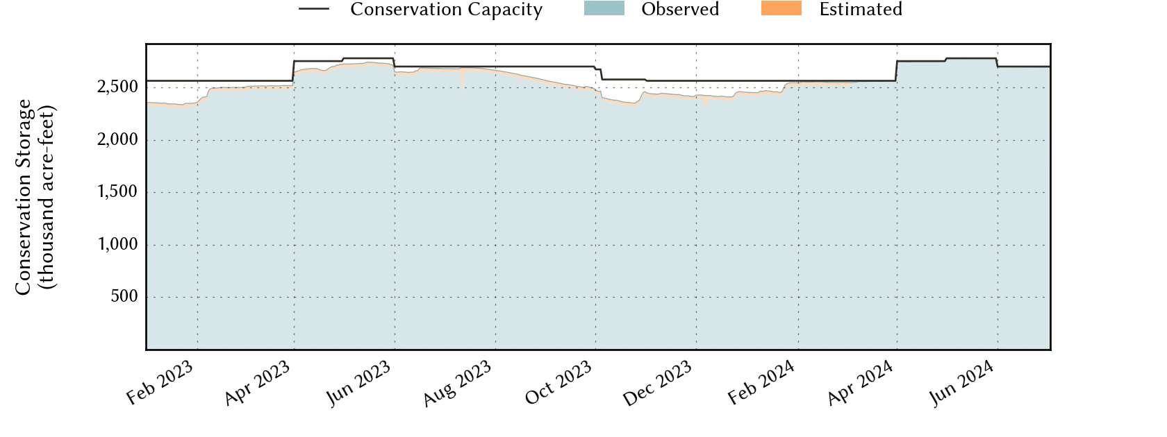
North-East-Texas Planning Region Reservoirs: Monitored Water Supply Reservoirs are 99.6% full on 2025-02-23
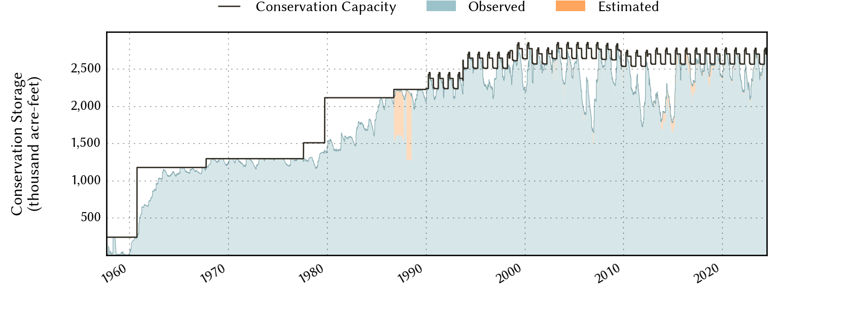
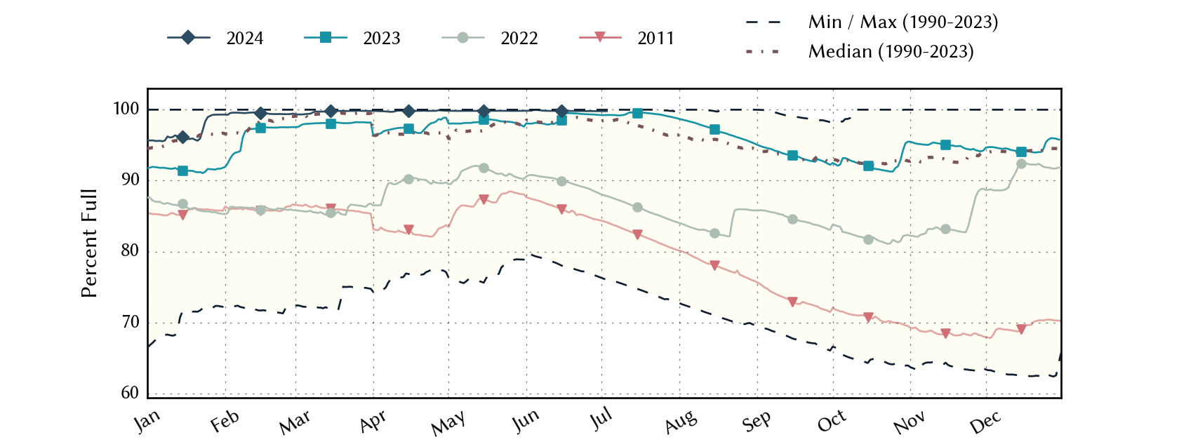
Historical Data
| Date | Percent Full |
Reservoir Storage (acre-ft) |
Conservation Storage (acre-ft) |
Conservation Capacity (acre-ft) |
|
|---|---|---|---|---|---|
| Today | 2025-02-23 | 99.6 | 3,019,486 | 2,553,590 | 2,563,861 |
| Yesterday | 2025-02-22 | 99.6 | 3,025,607 | 2,554,623 | 2,563,861 |
| 2 days ago | 2025-02-21 | 99.7 | 3,030,305 | 2,556,197 | 2,563,861 |
| 1 week ago | 2025-02-16 | 99.8 | 3,082,021 | 2,559,921 | 2,563,861 |
| 1 month ago | 2025-01-23 | 92.3 | 2,746,691 | 2,367,633 | 2,563,861 |
| 3 months ago | 2024-11-23 | 90.1 | 2,610,612 | 2,309,346 | 2,563,861 |
| 6 months ago | 2024-08-23 | 96.3 | 2,800,532 | 2,600,289 | 2,699,967 |
| 1 year ago | 2024-02-23 | 99.3 | 2,879,882 | 2,545,679 | 2,563,861 |
*
Percent Full is based on Conservation Storage and Conservation Capacity and doesn't account for storage in flood pool.
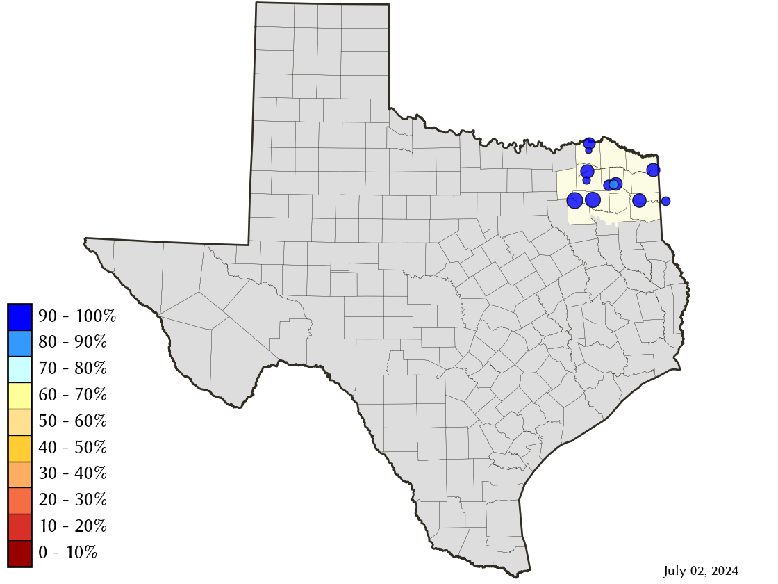
Area Map
Reservoir Storage
| Reservoir | Percent Full |
Water Level (ft) |
Height Above Conservation Pool (ft) |
Reservoir Storage (acre-ft) |
Conservation Storage (acre-ft) |
Conservation Capacity (acre-ft) |
Surface Area (acres) |
|---|---|---|---|---|---|---|---|
| Bob Sandlin | 100.0 | 337.88 | 0.38 | 206,540 | 192,417 | 192,417 | - n.a. - |
| Caddo 1 | 100.0 | 170.19 | 1.69 | 175,061 | 29,898 | 29,898 | 30,472 |
| Crook | 99.5 | 475.96 | -0.04 | 9,168 | 9,153 | 9,195 | 1,054 |
| Cypress Springs | 100.0 | 379.08 | 1.08 | 70,290 | 66,756 | 66,756 | - n.a. - |
| Fork | 99.0 | 402.78 | -0.22 | 630,695 | 599,252 | 605,061 | 26,269 |
| Jim Chapman | 100.0 | 440.01 | 0.01 | 294,678 | 258,723 | 258,723 | 18,004 |
| Lake O' the Pines | 100.0 | 230.47 | 1.97 | 277,401 | 241,363 | 241,363 | - n.a. - |
| Monticello | 87.3 | 337.72 | -2.28 | 30,320 | 30,320 | 34,740 | 1,795 |
| Pat Mayse | 100.0 | 452.06 | 1.06 | 123,881 | 113,683 | 113,683 | - n.a. - |
| Sulphur Springs | 100.0 | 459.45 | 0.50 | 18,735 | 17,747 | 17,747 | - n.a. - |
| Tawakoni | 100.0 | 438.01 | 0.51 | 890,689 | 871,685 | 871,685 | - n.a. - |
| Wright Patman | 100.0 | 226.95 | 6.35 | 292,028 | 122,593 | 122,593 | - n.a. - |
footnotes
1
Caddo Lake straddles the border of Texas and Louisiana, Texas has rights to 50% of Lake Caddo's total conservation capacity. Percent full, conservation storage and conservation capacity are based on the Texas share.